
A Hot Topic: This Summer Could Be Sweltering
It could be a hotter summer for much of the US, according to New York Times meteorologist Judson Jones. In Phoenix, Arizona, where temperatures have already been in the 100s several times this year, things will only get hotter. That is, Phoenix is one of many places in the US that is likely to see higher than normal temperatures this summer.
From Maine to Florida to Texas, temperatures have a 50 to 60% chance of being above normal, in part due to extremely warm Atlantic waters. Bangor, Maine might see more mid-eighties highs; Miami might see more mid to upper-nineties; Houston might see upper-nineties and possibly peak into the 100s.
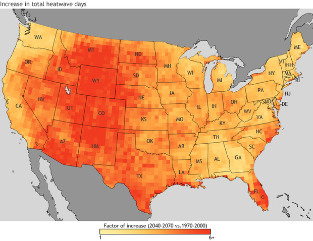
The highest chance for above average highs will be in the Southwest, namely the four corner states and western Texas. Las Cruces, in southern New Mexico, could hit the 110s on several occasions.
Canada won’t be spared either. Many predictions for their summer have the western and central provinces high above normal, with the eastern provinces slightly above normal. Parts of Ontario and Quebec have already seen highs 25 to 30 degrees above average this month, and the Northwest Territories hit mid 80s three times.
Even while Bostonians might be desperately fanning themselves, not all of the nation could have an above average summer. The upper Midwest will likely be right around normal, with equal chances to be above or below average (although temperatures could hit mid-nineties in many midwestern cities next week).
An almost rebirthed El Niño, which usually means less rain, could bring a hotter and drier summer to the West Coast. Because rainfall often has a cooling effect, a drier trend coupled with human-induced warming could bring upper eighties to many parts of Oregon, and possibly 100s farther from the coast.
The warm Atlantic waters, which will help heat up the eastern seaboard, will also mean stronger tropical systems. The National Hurricane Center has predicted a near-normal hurricane season, with up to four “major” hurricanes (Category 2-3 or higher). Warmer ocean temperatures stimulate their development, meaning that tropical systems could strengthen faster and live longer. Some Atlantic Ocean temperature models have the waters at half a degree above the previous record, so any systems that do form will have a higher chance to undergo rapid intensification.
Long-range weather models have shown a heightened risk of severe weather around Nebraska for June and July, although accuracy is low for models this far out. A hotter western third of the nation means that storms sweeping across the plains could start out with more energy. Combine that with high dew points pulled northward from the Gulf, and there’s storms popping left and right. Cities like McCook, Nebraska, which saw record-breaking low temperatures over the past winter, could see an increased number of thunderstorm days this summer.
NOAA has also released a fall outlook, which looks pretty similar to how the summer will go. The Southwest and Northeast have a 60 to 70% chance to be above normal, with the northern plains looking around average. From the Tennessee Valley up into southern Illinois could see above average precipitation, while the Northwest could be drier than normal.
Because global warming builds off of itself, future summers will likely be hotter. Data from the past century shows that, between the 1920s and the 1970s, summers remained around average. However, from the 70s to the present, summers have been getting warmer exponentially. Especially in the past decade, summers have been well above the century average.
While it is known that climate change is caused by people, not enough is being done to hamper the soon-to-come extreme effects. More regulations need to be in place on fossil-fuel businesses, more electric cars need to be on the road, and more efforts need to be put to preventing the worst effects.